Keepit Power Station
| Key Data | |
|---|---|
| Dam construction completed | 1958 |
| Hydro power station commissioned | 1960 |
| Dam operating capacity | 425.5 gigalitres |
| Dam height | 55 metres |
| Lake size | 44 square kilometres |
| Generation capacity | 7.2 megawatts |
| Approximate annual generation | 7.5 gigawatt hours |
Key Facts and History
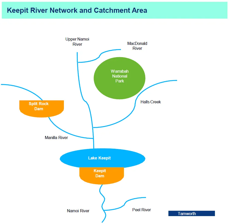
- Keepit Power Station is located near Tamworth in New South Wales.
- Keepit Dam was the first of three dams to be built in the Namoi Valley, to increase irrigation and supply town water. The other two are Chaffey on the Peel River and Split Rock on the Manilla River
- Maximum water capacity of 425 gigalitres, making it nearly as large as Sydney Harbour
- The dam has a catchment area of 5,700 square kilometres
- Original purpose of the dam was to boost agricultural production in the Namoi Valley
- Keepit Dam was proposed as early as the 1890s, and work finally began in 1939 however was halted in 1941 by World War II, with construction not completed until 1960
- Today, Keepit benefits crops from irrigation, specifically cotton, but water from the dam also assists with the growing of lucerne, cereals, oilseed, wheat and vegetations
- Several operational improvements have been made to Keepit Dam in more recent years
- In 2011 two additional spillways and three saddle dams were built to allow the dam to safely pass a rare and extreme flood
- Stage two of the upgrade was recently completed to strengthen the main dam wall
See images in the below gallery.
Power Station Overview
- Keepit Power Station operates a single 7.2 megawatt rated vertical Francis type turbine, rated at 33 metres net head. The turbine operates at a maximum flow rate of 2,100 megalitres per day
- The turbine is directly coupled to a single 7.5 megavolt ampere (MVA) water cooled generator unit which generates at 11 kilovolts (kV) at the terminals
- The terminals are connected to the main transformer in the switchyard, which was replaced in December 2013, via underground cables. The new transformer steps up the voltage to 66 kV distribution levels. A 72.5 kV circuit breaker connects to the 66 kV distribution line. The excitation system is used to control and maintain the output of the generator
- In 2013 the station completed a turbine overhaul and was equipped with a new generator transformer, excitation system and circuit breaker
- In 2019 a new LV switchboard was installed, and more recently a new station roof has been completed
- Anticipated operational improvements include replacing the auxillary transformer, new generator cables, protection upgrades and station automation
Water Supply
- Keepit Dam is located on the Namoi River, upstream of the confluence of the Namoi and Peel Rivers
- Lake Keepit lies within the Namoi catchment which has an area of about 42,000 square kilometres from the Great Dividing Range near Tamworth to the Barwon River near Walgett
- Streamflows in the Namoi catchment are regulated by the Split Rock Dam on the Manilla river. WaterNSW operates Keepit and Split Rock in order to meet water flow needs downstream of Keepit Dam
- Flows from the upper Namoi River (including inflows from the MacDonald River and Halls Creek) are unregulated
- Elevations in the catchment peak at just over 1,500 metres to the south and east
- The dam has a maximum capacity of approximately 425 gigalitres with a maximum depth of 48 metres at a nominal elevation of 329 metres above sea level. The spillway capacity of Keepit Dam is estimated to discharge 905 gigalitres per day
- Summer rainfall is higher due to monsoonal influences in the region
- Water releases are managed by WaterNSW to ensure that sufficient water can be supplied to water licence holders
- Water is required for established agricultural industries (particularly cotton) in addition to town supplies and flood mitigation
- The dam drains over the irrigation period (August-February) when water demand downstream is high. As a result, most generation also occurs over the irrigation period